Mariia Novoselia
Staff writer
From the pier by Miller Bell Tower, an orange pop of color can be seen in the water. But from the shore, it’s hard to tell what the floating thing is, let alone grasp the part it is playing in lake research.
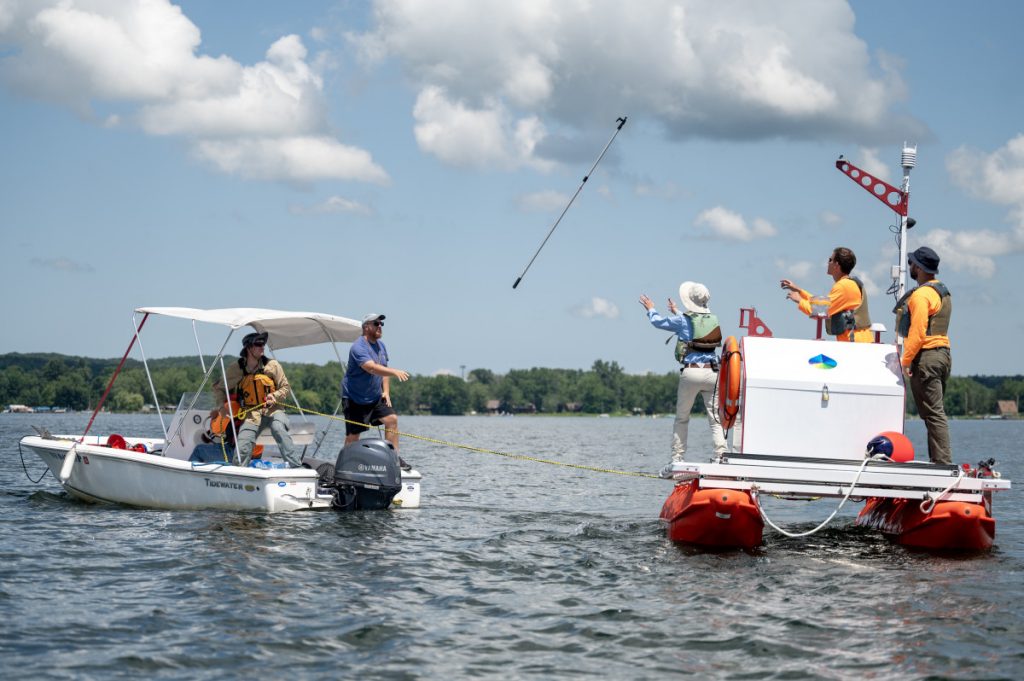
As part of an ongoing collaboration between Chautauqua Institution and The Jefferson Project, second-generation vertical profilers were installed on the lake Tuesday and Wednesday.
Researchers and project managers gathered at Long Point Tuesday to set one of the two units in the South basin of Chautauqua Lake. The next day, they repeated the process at Prendergast.
The Jefferson Project is a collaborative effort between Rensselaer Polytechnic Institute and IBM Research that started on Lake George, New York. Tobias Shepherd, lake project manager, said the Institution has been working with the project since 2020 and created a five-year agreement last year, effectively extending the partnership to at least 2026.
These vertical profilers, which include orange buoys, are comprised of several different instruments deployed into the lake during the summer, then taken away later in the year.
“One of the key things … is to have them in the same spot,” Shepherd said, noting that this is essential for getting consistent data for research.
At the annual Chautauqua Lake Water Quality Conference held in June, IBM fellow Harry Kolar described these vertical profilers as “state of the art.”
Shepherd said funding came from a combination of sources, including members of the community and the Chautauqua Lake & Watershed Management Alliance, among others. Chautauqua County, Shepherd said, has contributed $1 million to the project this year, and the Institution is also pursuing support from the state.
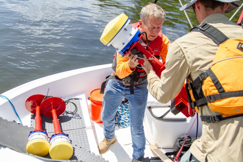
This year’s vertical profilers are different from those used last year, said Brian Mattes, senior research specialist at The Jefferson Project.
“They have been completely improved,” he said.
The new units include higher visibility, higher frequency of data collection and larger size of “the doghouse” – a portion of the profiler that holds all the instruments, Mattes said.
Each profiler station has special sensors, called Turner Fluorometers, mounted at the surface level, he said, that will identify algae blooms.
Three Acoustic Doppler Current Profilers have also been added to the new units — “real stars of the project,” Mattes said, which are also attached at the surface.
“(They) send out a ping, and the ping bounces off all the different particles in the water, and then the signal that it receives back (helps us) to understand the flow rate and direction of water,” he said. “Acoustics are really important because we’re able to model the entire water physics that are happening below.”
Described by Mattes as “the bread and butter,” a sensor sonde — a probe that looks like a blue tube — will travel through the water, from the doghouse, stopping a few feet above the bottom of the lake, constantly taking measurements and creating a profile of the lake.
Altogether, the new vertical profilers, Mattes said, will provide scholars researching the lake with over 100 parameters, including water quality, clarity, salinity, levels of pH and more.
Not only are these vertical profilers upgraded from last year, the models put in the North and the South basins of the lake are not identical. “Half-moon,” or the vertical profiler in the South basin, has an auxiliary buoy that “Endurance,” the other vertical profiler, doesn’t.
The additional buoy will have a wet-chemistry phosphorus sensor, said Mark Lucius, software engineer at RPI. In the South basin, he said, there are ephemeral stratification events, when the oxygen is depleted toward the bottom and phosphorus is released from the sediment. Water stratification, he explained, occurs when multiple layers of water that don’t mix well develop. In most cases, this is due to the difference in temperature, but other factors include density gradient, salt contents and so on.
Shepherd said it’s exciting to have the buoy, since the amount of phosphorus in the lake has been a significant issue.
Phosphorus is largely responsible for the New York State Department of Environmental Conservation granting Chautauqua Lake the “impaired” status. Shepherd said the state issues a “Total Maximum Daily Load” document, and Chautauqua Lake has exceeded the norm for phosphorus. He said getting off the list of impaired lakes within the next 10 years “will be a challenge.”
“The physical makeup of the lake has been relatively high in nutrients for as long as we can tell,” he said. “(Mitigating it) will take a while, even if we make the smartest decisions.”
Shepherd said perhaps a bigger concern for the lake right now is harmful algae blooms, or HABs. While the causation between phosphorus and algae blooms is present, he said, it may be not as simplistic as researchers once thought. Still, more phosphorus in the lake affects the number of HABs.
“The whole point is not science for science, it’s science for solution,” Shepherd said. “We need to get our arms around HABs … for us to be able to invite the community, for us to be able to use the lake safely and enjoy the place for decades to come.”
This buoy, Lucius said, will be a good source of information on nutrient loading.
“We’ve had models sort of predict (amounts of phosphorus from internal loading), but we’ve never had a hard physical measurement,” Shepherd said. “So, we’re hopeful that that sensor we deployed yesterday will give us good empirical data.”
Internal loading refers to how sediment already in the lake gets “disrupted or stirred up.” Researched together with atmospheric deposition – nutrients mixed into the lake – and watershed loading – how nutrients are washed into the lake through storms – this will help scientists create a nutrient budget.
A nutrient budget, Shepherd said, establishes how many nutrients are in the water, where they are coming from, and more – it represents the dynamics of the lake.
Shepherd noted how crucial, and expansive, the systems’ new capabilities were for research: “If all that data was coming into my laptop, it would just break.”
Along with the vertical profilers, Mattes said the team hopes to deploy tributary monitoring stations in the streams flowing into the lake later this summer.
“We have to understand the amount of nutrients that are getting into the lake before we can really understand what’s happening in the lake,” he said.
Vertical profilers will remain in the lake until late November.
Mattes asked Chautauquans to try and stay away from the machines and not “throw a huge wake” at them. People who fish, he said, need to know that there are lines attached to the profilers that run over 190 feet deep into the lake. He asked that boaters not pull the lines out if they do get hooked.